Glaciation
National Curriculum:
Understand, through the use of detailed place-based exemplars at a variety of scales, the key processes in physical geography relating to glaciation.
GCSE Specification:
AQA (A)- Understand how ice has changed in the past and is dependent on the glacial budget. Case study of a glacier- recent retreat since nineteenth century: causes and evidence. Case study of an Alpine area for winter sports and sightseeing glaciers with economic, social and environmental impacts.
AQA (B)- Understand the nature of cold environments and where to find them. Study an area where glaciers are retreating or shelves are shrinking.
Edexcel (A)- Understand the negative impacts of climate change on glaciers.
A-Level Specification:
AQA- Understand the global distribution of cold environments- polar, alpine, glacial and per-glacial. Study glacier systems and glacial processes and landscape developments as well as erosional landforms.
Edexcel- Understand the long term evidence of global warming (glacial changes).

Subject knowledge:
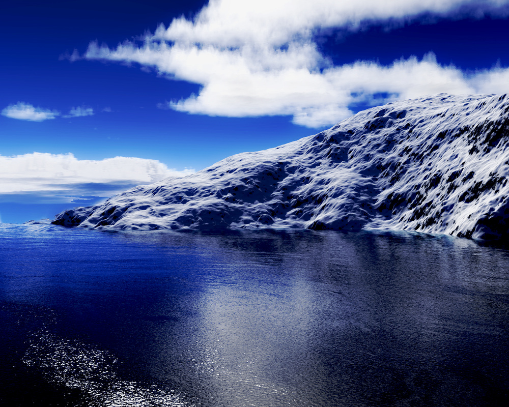
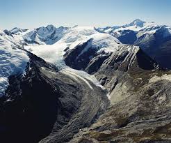
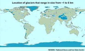
A glacier is a mass of ice that moves very slowly downhill. They are found at high altitudes all over the globe; including near the equator. The formation of glaciers and the process by which they shape the landscape around them is called glaciation. Glaciers are formed in upland areas where snow remains on the ground all year. As more and more snow is added it compresses to form ice. In some areas, enormous ice sheets cover the whole landscape (the whole of northern Britain was covered in ice during the Ice Age). In other places, ice only fills the valleys, forming glaciers. These glaciers move downhill and have the capability to shape the landscape. During the last ice age the temperature remained below 0°C which allowed the ice to remain on the land all year. Glaciers once covered large areas, 20,000 years ago over 30% of the Earth's land surface was covered by ice including nearly all of the UK! The legacy of ancient glaciers lives on - for example in areas such as the Lake District (Possible field trip). We're currently in an interglacial period that began around 10,000 years ago. Today about 10% of the land is covered in ice. Ice and snow still permanently cover countries within the Arctic circle, such as in Greenland and parts of Russia. Ice sheets are huge masses of ice that cover whole continents whereas glaciers are masses of ice that fill valleys and hollows.
Location of glaciers:
Glacial budget:
A glacier has a zone of accumulation and a zone of ablation. Accumulation is the input of snow and ice into the glacier. Ablation is the output of water from a glacier as the ice melts. You get more accumulation that ablation in the upper part of a glacier- so it's called the zone of accumulation. You get more ablation than accumulation in the lower part of a glacier- so it's called the zone of ablation.
A glacier has a zone of accumulation and a zone of ablation. Accumulation is the input of snow and ice into the glacier. Ablation is the output of water from a glacier as the ice melts. You get more accumulation that ablation in the upper part of a glacier- so it's called the zone of accumulation. You get more ablation than accumulation in the lower part of a glacier- so it's called the zone of ablation.
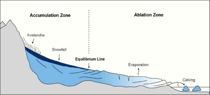
The glacial budget is the difference between total accumulation and total ablation for one year. The amount of ice in a glacier, and where it is advancing or retreating depends on the glacial budget:
- A positive glacial budget is when accumulation (input) exceeds ablation (output). The glacier gets larger and the bottom of the glacier advances down the valley.
- A negative glacial budget is the opposite. The ablation (output) exceeds accumulation (input) and the glacier gets smaller and retreats up the valley.
|
Retreating ice:
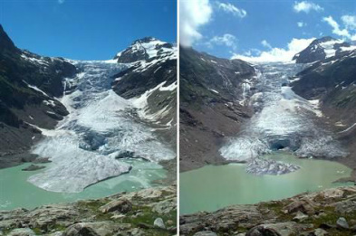
As a result of increasing temperatures due to climate change, glaciers all over the world are retreating. This can be observed in the Alps, Rockies, Andes and Himalayas. The retreat of glaciers since 1850 (post little ice age) affects the availability of fresh water for irrigation and domestic use, mouton recreation, animals and plants that depend on glacier melt, and in the long term, the level of the oceans. The Bossons Glacier in Chamonix, France, has retreated 1,200 m from extents observed in the early 20th century (see picture to the right). There are many discussions debating whether this is all the result of global warming and the extent to which human activity is responsible. There's a consensus among scientists that glacial retreat is caused by global warming. |
|
Glacial erosion:
1) Glaciers form in hollows on the colder, sheltered side of a mountain. These hollows are called corries.
2) Snow and ice gathers in the hollows and over time the cores gets larger through freeze-thaw weathering. Freeze- thaw weathering also loosens pieces of rocks which fall onto the glacier. This material is called moraine (See video above).
3) Eventually the ice will move out of the corrie ad over the lip of the hollow. The glacier moves down the mountainside. At the front of the glacier is the snout. A lake called a tarn, may from in the corrie.
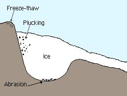
4) As the glacier moves it erodes the landscape in two ways: abrasion and pucking.
1) Glaciers form in hollows on the colder, sheltered side of a mountain. These hollows are called corries.
2) Snow and ice gathers in the hollows and over time the cores gets larger through freeze-thaw weathering. Freeze- thaw weathering also loosens pieces of rocks which fall onto the glacier. This material is called moraine (See video above).
3) Eventually the ice will move out of the corrie ad over the lip of the hollow. The glacier moves down the mountainside. At the front of the glacier is the snout. A lake called a tarn, may from in the corrie.
4) As the glacier moves it erodes the landscape in two ways: abrasion and pucking.
|
Abrasion: This occurs when pieces of rock carried by the ice wear away the landscape. As a glacier moves, it transports material with it, which helps the glacier erode the bedrock and shape the landscape. The material can be frozen within the glacier found underneath it. It leaves behind smooth polished surfaces which may have scratches in them called striations. Striations are carved out by angular debris embedded in the base of the glacier.
Pucking: Occurs when meltwater under a glacier freezes on to the rock surface. As the glacier moves forward, it pulls away large fragments of rock from the surface. |
|
Erosional landforms:
Glaciers have a huge impact on landscapes. They exert colossal forces on the land and are responsible for dramatic changes caused by erosion.
Glacial trough: Glaciers cut distinctive U-shaped valleys with a flat floor and steep sides. The glacier widens, steepens, deepens and smoothes V-shaped river valleys, eg Great Langdale Valley in the Lake District.
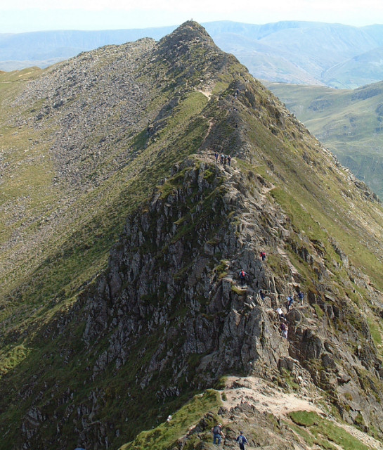
Arête: An arête is a knife-edge ridge. It is formed when two neighbouring corries run back to back. As each glacier erodes either side of the ridge, the edge becomes steeper and the ridge becomes narrower, eg Striding Edge found on Helvellyn in the Lake District.
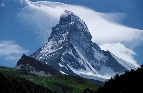
Pyramidal peak: A pyramidal peak is formed where three or more corries and arêtes meet. The glaciers have carved away at the top of a mountain, creating a sharply pointed summit, eg Mont Blanc, The Matterhorn and Mount Everest.
Glaciers have a huge impact on landscapes. They exert colossal forces on the land and are responsible for dramatic changes caused by erosion.
Glacial trough: Glaciers cut distinctive U-shaped valleys with a flat floor and steep sides. The glacier widens, steepens, deepens and smoothes V-shaped river valleys, eg Great Langdale Valley in the Lake District.
Arête: An arête is a knife-edge ridge. It is formed when two neighbouring corries run back to back. As each glacier erodes either side of the ridge, the edge becomes steeper and the ridge becomes narrower, eg Striding Edge found on Helvellyn in the Lake District.
Pyramidal peak: A pyramidal peak is formed where three or more corries and arêtes meet. The glaciers have carved away at the top of a mountain, creating a sharply pointed summit, eg Mont Blanc, The Matterhorn and Mount Everest.


Glacial depositions:
1) As a glacier moves downhill, temperatures rise and glaciers begin to melt.
2) As it begins to melt it deposits the material that it has been carrying which usually takes place in lowland areas which creaks a number of distinctive landscape features.Moraine: is the rom material carried by the glacier. It is later deposited to form mounds of unsorted rocks and rock particles which are known as moraines. There are different types of moraine which are classifies according to when and where they were deposited. Lateral moraine are found at the sides, medial moraine are found when two glaciers join and terminal moraine are found at the end of glaciers.
Glacial deposition landforms:
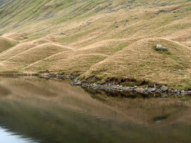
Drumlins: are mounds of boulder clay, deposited by glaciers and shaped by the moving ice. The ice moved over the drumlins to form small egg shaped hills.
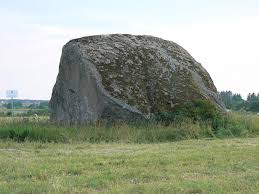
Erratics: are rocks transported many miles by a glacier and later found in an area of a different rock type.
1) As a glacier moves downhill, temperatures rise and glaciers begin to melt.
2) As it begins to melt it deposits the material that it has been carrying which usually takes place in lowland areas which creaks a number of distinctive landscape features.Moraine: is the rom material carried by the glacier. It is later deposited to form mounds of unsorted rocks and rock particles which are known as moraines. There are different types of moraine which are classifies according to when and where they were deposited. Lateral moraine are found at the sides, medial moraine are found when two glaciers join and terminal moraine are found at the end of glaciers.
Glacial deposition landforms:
Drumlins: are mounds of boulder clay, deposited by glaciers and shaped by the moving ice. The ice moved over the drumlins to form small egg shaped hills.
Erratics: are rocks transported many miles by a glacier and later found in an area of a different rock type.


Glacial landforms:
Glaciation helped to create distinctive and interesting landscapes such as the Lake district. Tourists and day visitors may visit these areas to go walking, hiking, mountain climbing or absailing. Many landscapes created by glaciation are protected from large-scale urban or industrial development. Many are national park in rural areas, where the main land use is for primary industry, such as farming or mining. Conflicts can occur between different groups using the land, for example: tourists create traffic and farmers want to protect the land.
Glaciation helped to create distinctive and interesting landscapes such as the Lake district. Tourists and day visitors may visit these areas to go walking, hiking, mountain climbing or absailing. Many landscapes created by glaciation are protected from large-scale urban or industrial development. Many are national park in rural areas, where the main land use is for primary industry, such as farming or mining. Conflicts can occur between different groups using the land, for example: tourists create traffic and farmers want to protect the land.
|
Tourism:
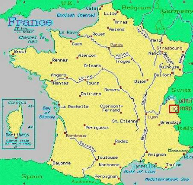
Tourism in glaciated areas: The French Alps - Chamonix Chamonix is located on the North-Western part of the French Alps, 15 km from the Swiss border and 15km from the Italian border. The area is dominated by Mont Blanc which stands at 4,808m tall and attracts up to 100,000 tourists in the summer and 60,000 in the winter. Activities include skiing, snowboarding, ice climbing and, in the summer, rock climbing, mounting biking and canyoning. Tourists bring lots of economic benefits; employment for local people in hotels and restaurants, in sports facilities, as guides and instructors and keeps local businesses alive. In addition, local people are able to benefit from the improved facilities. However, due to it being a predominately tourist area, prices are higher and locals are forced to pay these prices in shops. Further to this, houses are expensive as they are aimed at wealthy people for second homes. Due to the high number of visitors, the land has becoming eroded especially around footpaths. |
|
There's need to conserve fragile environments, but people also have the right to see and experience it. There are different strategies to manage the environment so the impacts are reduced:
- Tourists should be kept informed of the risks associated with avalanches. Resorts should plant trees and and building structures that can divert and slow down moving snow.
- Improvements to public transport systems can reduce the amount of traffic and so reduce damage to the environment from pollution.
- Areas can also be set up as nature reserves which limited the activity in the areas so the environmental impact is reduced.
Teaching and Pedagogy:
Create a spider diagram including all the information that you already know about glaciation, this could include a definition, where you might find them, a diagram etc. At the end of each lesson you will come back to this and add what you have learned. This will become a useful revision tool.
a) Match the following landforms to to their correct names: Drumlins, Erratics, Glacial Troughs, Arete and Pyramidal Peak. Once complete, highlight which ones are created by erosion and deposition.

b) Create an in-depth casestudy, with diagrams, sketches and photos, of evidence of glacial activity in the Lake District (following field trip).
c) Add to your spider diagram.
a) Label the following diagram. Give students a blank diagram of the glacial budget and ask them to label it.
b) You've been hired by the French government to take control of a new ski resort. Create a poster to demonstrate to locals how you will manage the social, economic and environmental problems that many resorts have faced in the past. More able students might be able to write a letter as well.
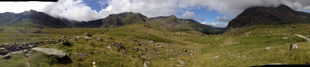
Identify the glacial features in the following picture (@internetgeog):
c) Add to your spider diagram.
a) Label the following diagram. Give students a blank diagram of the glacial budget and ask them to label it.
b) You've been hired by the French government to take control of a new ski resort. Create a poster to demonstrate to locals how you will manage the social, economic and environmental problems that many resorts have faced in the past. More able students might be able to write a letter as well.
Identify the glacial features in the following picture (@internetgeog):
Example powerpoint for KS3 lesson on corries:
|
Past papers:
A-level: a) With the help of diagrams, describe drumlins (5 marks) b) Explain the formation of drumlins (8 marks) GCSE foundation: a) Draw a labelled sketch to show the characteristics of a drumlin ( 3 marks). b) Explain the formation of a drumlin (5 marks). |
GCSE foundation: a) Suggest why glacial areas are popular with tourists (3 marks) b) Using a specific case study, explain how tourists can damage these fragile environments (8 marks) GCSE Higher: a) Using geographical terms, explain how a glacier erodes the landscape. (5 marks) b) For a named glaciated environment that you have studied, describe how the land is used by tourists and explain why conflicts may occur between different groups of people using that landscape. (10 marks) |
